- CA ON00156 2014-49/31
- Documento
- 1910-1932
Parte de Smith family photographs
Black and white photographs of varying size. Photos taken in Ottawa, Ontario. Place names are written on the photos.
201 resultados diretamente relacionados Excluir termos específicos
Parte de Smith family photographs
Black and white photographs of varying size. Photos taken in Ottawa, Ontario. Place names are written on the photos.
Parte de Smith family photographs
Black and white photographs of varying size. Photos taken throughout Ontario, Canada. Place names are written on the photos. Napanee, Gananoque, St. Ann, North Bay, Welland Canal, Massey, Point Traverse, Sault Ste. Marie
Parte de Smith family photographs
Black and white photographs of varying size. Photos taken at different locations throughout Quebec. Montreal, Gaspe and Quebec City. Place names are written on each photograph.

Parte de Map collection
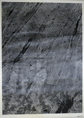
A reproduction of an air survey photograph produced by the Ontario Ministry of Natural Resources. Map # 444773E of Rawdon Township in Hastings County, Ontario. Circa 1950.
The photograph shows Rawdon Township from the eastern border to Hwy 14, Harold and Springbrook Villages, western Huntingdon Township, southern Marmora and Madoc Townships, Banker Lake.
Donated by Walter I. Watson, P.L.S.
Sem título

Parte de Map collection
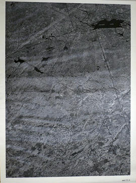
A reproduction of an air survey photograph produced by the Ontario Ministry of Natural Resources. Map # 444773W of Rawdon Township in Hastings County, Ontario. Circa 1950.
The photograph shows Rawdon Township, Concession 8 to 14, west of Hwy 14, small sections of Marmora Township including Marmora Village and Crow Lake and a small part of Seymour Township in Northumberland County
Donated by Walter I. Watson, P.L.S.
Sem título
Sheffield Township Map # 445771E
Parte de Map collection
A reproduction of an air survey photograph produced by the Ontario Ministry of Natural Resources. Map #445771E of Sheffield Township in Lennox and Addington County, Ontario. Circa 1950.
The photograph shows Sheffield Township, Concession 3 to 9, Beaver Lake and north to Kaladar Township, Concession VIII to XI, Lingham Lakes in Grimthorpe Township in Hastings County.
Donated by Walter I. Watson, P.L.S.
Sem título
Elzevir Township Map # 446772E
Parte de Map collection
A reproduction of an air survey photograph produced by the Ontario Ministry of Natural Resources. Map #446772E of Elzevir Township in Hastings County, Ontario. Circa 1950.
The photograph shows the North East part of Elzevir Township, Elzevir Creek and the Skootamata River.
Donated by Walter I. Watson, P.L.S.
Sem título

Hydrographic Map of Plans in Bay of Quinte
Parte de Map collection
A hydrographic map of Plans in the Bay of Quinte, Ontario, Canada. 4 inset maps are included of the 1) Trenton and Approaches, 2) Belleville, 3) [Racist slur redacted] Narrows, and 4) Telegraph Narrows. Nautical surveys completed by Col. W. P. Anderson in 1893 and Mr. E. A. Ghysens in 1934. Map printed March 25, 1952. Published by the Canadian Hydrographic Service, Department of Mines and Technical Surveys, Ottawa.
Sem título

Reforestation Land and Existing Woodland in the Moira Watershed
Parte de Map collection
3 parts of a map entitled "Source Areas [of] Reforestation Land and Existing Woodland" in the Moira Watershed. The varieties of land use include existing woodland, scrub areas, source areas, crown land, and timber licences. Published by the Ontario Department of Planning Development, Conservation Branch in 1950.
Sem título
Air Surveys of Stirling, Ontario
Parte de Map collection
All air surveys were completed in 1984 and published in 1985. Scale 1 inch = 2000 feet. By the Ontario Ministry of Natural Resources, Map base by Survey and Mapping Branch, Air Photography.
1) M470-2683. Stirling, Sheet # 1, 02-18-2960-49060 showing areas of; the Village of Stirling, Sidney Township Lot # 20, Concession 9, with Rawdon Creek along the Westerly section of the map.
2) M470-2684. Stirling, Sheet # 2, 02-018-2950-49070 showing areas of; the Village of Stirling, Lots # 18, 19, 20 Concession 9 of Sidney Township and Lots # 14, 13, 12 Concession 1, Rawdon Township.
3) M470-2685. Stirling, Sheet # 3A, 02-18-2960-49070 showing areas of; the Village of Stirling, Lots # 21, 22, 23 Concession 9, Sidney Township, Lot # 12 Concession 1, Rawdon Township. Also, the Mill Pond of Rawdon Creek on Lot # 10 & 11, Concession 1, Rawdon Township.
4) M470-2686. Stirling, Sheet # 3B, 02-18-2960-49070 showing areas of; the Village of Stirling, Lots # 21, 22, 23 Concession 9, Sidney Township, Lot # 12 Concession 1, Rawdon Township. Also, the Mill Pond of Rawdon Creek on Lot # 10 & 11, Concession 1, Rawdon Township.
5) M470-2687. Stirling, Sheet # 4, 02-18-2970-49070 showing areas of; the Village of Stirling and Sidney Township.
6) M470-2688. Stirling, Sheet # 5, 02-18-2960-49080 showing areas of; the Village of Stirling and Rawdon Township; Lots # 12, 11, 10 Concession 1.
7) M470-2689. Stirling, Sheet # 6, 02-18-2970-49080 showing areas of; the Village of Stirling and Rawdon Creek.
Sem título
Ontario Aerial photographs 1972-1977
Parte de Map collection
Aerial photographs showing various townships within Ontario in the 1970s.
Map of the Tyendinaga Mohawk Reserve
Parte de Map collection
A laminated photocopy of a map of the Tyendinaga Mohawk Territory, circa 1960.
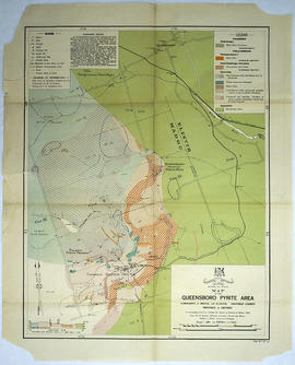
Map of the Queensboro Pyrite Area
Parte de Map collection
An original map of the Queensboro area, indicating specific geological areas and signs. Includes the Townships of Madoc and Elzevir in the County of Hastings, Ontario. Dated 1913. Published by the Ontario Department of Lands, Forests and Mines. Scale: 800 feet to an inch.
Donated by David Pershik.
Sem título
Parte de Map collection
Map showing Upper Canada settlements in 1835. From the Archives of Canada.
Map of Essex County (Southwestern Ontario)
Parte de Map collection
A map showing Essex County in southwestern Ontario, 1887. It features information and reference to railways at the time. Published and donated by S.R.G. Penson.
Received from the Archives of Canada's map collection - 27 Jul. 1966.
Sem título
Counties from Belleville to Ottawa
Parte de Map collection
A map showing counties from Belleville to Ottawa, Ontario, 1887. Published and donated by S.R.G. Penson.
Received from the Archives of Canada's map collection - 27 Jul. 1966.
Sem título
Teacher's Guide to Quinte in 1785
Parte de Map collection
Map showing the Bay of Quinte to Presqu'ile to the eastern tip of Grande Isle (Wolfe Island) used as a teacher's guide to the area in 1785. The 20th century names are in capital letters as per the Legend.

Map of the Moira Region Watershed
Parte de Map collection
A map of the Moira Region Watershed. Polychrome colours symbolize the varieties of soils and land use surveys, see Legend. Not dated, circa 1950. Published by the Ontario Department of Planning and Development, Conservation Branch. Dimensions 58.5cmx 69cm.
Sem título

South and Central Hastings Map
Parte de Map collection
"Cummins Rural Directory Map:" A map of South and Central Hastings, in 1923, featuring post offices, hamlets and lot owners. Map is surrounded by advertisements. Published by Cummins Map Co., Toronto. Dimensions 71cm x 50.5cm.
Sem título
Map of Belleville to North of Bancroft
Parte de Map collection
A map containing focused maps of: Trenton, Belleville, Prince Edward County, Frankford, Picton, Bancroft, Deseronto, Stirling, Tweed, Marmora and Madoc. Insets refer to roads, streets and highways. Published by Millhouse Maps in 2001.
Sem título