Geographic features

Taxonomy

Code

Scope note(s)

Source note(s)

Display note(s)

Hierarchical terms

Geographic features

Equivalent terms

Geographic features

Associated terms

Geographic features

201 Archival description results for Geographic features

201 results directly related Exclude narrower terms

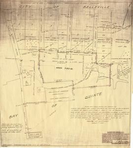
Map of Parcel of Area #1 - Land Settlement

"In the High Court of Justice - Chancery Division - Morton vs. Ponton. Sketch of Parcel No. ,1 referred to in advertisement of sale therein. "

A map showing a parcel of land between the Bay of Quinte and Dundas Street East (Area #1) in Belleville, Ontario. Published in 1881. Used in land settlement matters. Printed on tissue paper. Scale: 8 chains to an inch.

Map of planned Belleville Harbour

A map showing a plan for the Belleville Harbour. The total area stretches from south Front Street to the Ponton Plan. Published by John T. Ransom on May 19th, 1947. The map features field notes of survey of lands, marshes and Bay of Quinte waters. Scale: 1':100'.

Ransom, John Thomas, P.L.S.

Map of Railway Station, Harbour and Wharf Facilities

A map detailing the Grand Trunk Railway's station (1882), harbour and wharf facilities (1878) in Belleville, Ontario. Legends on each side of the maps describe buildings and areas. By William Michaud.

Michaud, William

Map of the Moira Region Watershed

A map of the Moira Region Watershed. Polychrome colours symbolize the varieties of soils and land use surveys, see Legend. Not dated, circa 1950. Published by the Ontario Department of Planning and Development, Conservation Branch. Dimensions 58.5cmx 69cm.

Ontario. Department of Planning and Development

Map of the Moira Watershed

A map of the Moira Watershed showing conservation areas, authority forests and the location of large bodies of water.

Map of the Queensboro Pyrite Area

An original map of the Queensboro area, indicating specific geological areas and signs. Includes the Townships of Madoc and Elzevir in the County of Hastings, Ontario. Dated 1913. Published by the Ontario Department of Lands, Forests and Mines. Scale: 800 feet to an inch.

Donated by David Pershik.

Ontario. Department of Lands and Forests

Map of the Trent Port

Map showing a sketch of the Trent Port - June 12th, 1837. Scale: 2 chains to an inch. Published by the Office of the Surveyor General.

From the Archives of Ontario in Toronto.

Map of Townships by waterfront and Mohawk Territory

Map showing townships by the waterfront of the Bay of Quinte and the Mohawk Territory. This area encompasses townships in both Prince Edward and Hastings Counties. Text on map says "District of Nassau." Dated 1790. Map copied from the Archives of Ontario.

Map of Upper Canada and United States

A map showing settlements of Upper Canada and part of the United States in 1834 by J. Arrowsmith.
Received from the Archives of Canada's map collection - July 9, 1971.

Arrowsmith, John

Map of Water Lots in Moira River and Bay of Quinte

A map showing a plan and additional field notes about water lots in the mouth of the Moira River and Bay of Quinte. The total area stretches from the mouth of the Moira River to south Front Street to Mary Street. Published by Thomas S. Ransom on July 31, 1961. The map was used for the installation of sewer lines. Scale: 1':100'.

Ransom, Thomas Saunders, P.L.S.

Map of Watersheds of the Moira and Napanee Rivers

A map of the Watersheds of the Moira and Napanee Rivers, 1950. From the Department of Planning and Development by A. H. Richardson, Chief Conservation Officer. Dimensions: 48cm x 35.5cm.

Richardson, A.H.

Map order form - Ministry of Transportation

A map order form from Ministry of Transportation allowing the purchase of maps from the Lithograph Series and the Ontario Transportation Series. Maps cover areas in Southern Ontario.

Ontario. Ministry of Transportation

Maps of Belleville on the Bay of Quinte

  • CA ON00156 M/M440-1367, 1391-1392, 1826
  • Item
  • 2000-2010
  • Part of Map collection

Each map was published by the Ontario Mapping Company and features advertisements, streets, transit routes and points of interest.

1) M440-1367. Dated from 2000-2001. Scale 2.5 cm : 0.5 km. Composed by the Belleville & District Chamber of Commerce.
2) M440-1390. Dated from 2008-2009.
3) M440-1391. Dated from 2006-2007.
4) M440-1392. Dated from 2003-2004.
5) M440-1826. Dated 2010.

Ontario Mapping Company

Maps of the Districts of Upper Canada

4 maps showing the Districts of Upper Canada between 1788-1849:

  1. Province of Upper Canada, original districts of 1788 and districts in 1802 (District boundaries 1788, dotted line, District boundaries 1802, solid line)
  2. Province of Upper Canada, original counties, ca. 1793
  3. Province of Upper Canada, districts in 1836
  4. Province of Canada West, districts in 1849

Marmora Township Map # 445773W

  • CA ON00156 M/M470-2591 - 2616/2610
  • Item
  • c. 1950
  • Part of Map collection

A reproduction of an air survey photograph produced by the Ontario Ministry of Natural Resources. Map #445773W of Marmora Township in Hastings County, Ontario. Circa 1950.

The photograph shows Marmora Township, Crow Lake, and north to Thompson Lake.

Donated by Walter I. Watson, P.L.S.

Ontario. Ministry of Natural Resources and Forestry

Results 81 to 100 of 201