- CA ON00156 CH/13/1/8
- Item
- 1886
Part of County of Hastings records
Digital copy of 1886 Directory of the Counties of Frontenac, Hastings, Lennox, Addington, Prince Edward
19 results directly related Exclude narrower terms
Part of County of Hastings records
Digital copy of 1886 Directory of the Counties of Frontenac, Hastings, Lennox, Addington, Prince Edward
Ontario Historical Society Records, Vol. XLV, #3, 1953
File contains a print copy of Ontario Historical Society Records, Volume XLV Number 3. This issue includes information about Molly Brant, a Loyalist; Kingston's French Heritage; information about Toronto; a Trip to Upper Canada, 1835; Archives and Museum news; and information about the annual meeting.
Sherwood, Samuel (Day Book 1784-1824)
The file contains a typed copy of Samuel Sherwood's account book. Included is a brief biography as well as a genealogy of Samuel, his wife and children, dated from 1754-1924.

Slides of Belleville and Ontario scenes
Slides made by Rudolf Donninger during his time in Belleville, Ontario, working at Northern Electric. They include photographs of buildings in Belleville, rural scenes, cars, a parade and the Belleville Fair in 1970, winter scenes, Ottawa and Kingston views, and aircraft at the Trenton Air Show.
Donninger, Rudolf
Topographical map of Tichborne
Part of Map collection
A topographical map of Tichborne - Canada sheet #31 C/10 - west half. Published by the Army Survey Establishment, Department of National Defence in 1950. Scale 1:50,000.
Canada. Department of National Defence
Part of Map collection
A topographical map of Sydenham - Canada sheet #31 C/7- both east and west half sheets. Published by the Army Survey Establishment, Department of National Defence in 1950. Scale 1:50,000.
Canada. Department of National Defence
File contains a pamphlet announcing the 1961 publication of Kayonakonte: 'Daughter of the Gods' by poet Wallace Havelock Robb, based on a Mohawk tradition.
Robb, Wallace Havelock

Panoramic photograph of the Hastings and Prince Edward Regiment
Photograph taken at Camp Barriefield, Ontario.
Marrison Studio
The file contains three newspaper clippings about the Royal Visit of Queen Elizabeth II and Prince Philip to Kingston. Included in the articles are references to the Tyendinaga Mohawk Territory and presentations by the Indigenous people. Also, during the same visit, in Toronto the meeting of the Royals with Peter Ramsay of Madoc.
Part of an architectural analysis of the Ford Block in Kingston
Part of an architectural analysis by Jennifer McKendry of the Ford Block at 165 Wellington Street, Kingston, Ontario, a building which was converted into a bank in 1895. The bank had a similar layout to the Bank of Montreal in Deseronto and the analysis includes a plan of the first floor of the bank.
McKendry, Jennifer

Rebellion, 1838 : warrants for witnesses against Nelson Reynolds and Hugh Scanlon
File contains a completed printed warrant for witnesses to appear in Midland District Court in Kingston on May 30, 1838 at a trial of Nelson Reynolds and Hugh Scanlon on charges of high treason.
Road Map of Belleville, Trenton, Kingston, 2010
Part of Map collection
A Road Map of Belleville, Trenton, Kingston in 2010. Scale 1cm : 0.25 km. Composed by Peter Heiler Ltd. Published by Map Art Publishing.
Part of Map collection
A double-sided map of the accommodations, camping and attractions located in Land O' Lakes. Includes North & West of Kingston including Napanee, the Frontenacs, Loyalist Country & Mazinaw Country. Advertisements surround the map. Dated 1982.

Topographical Map of Ontario - Belleville Sheet
Part of Map collection
A map of Hastings, Prince Edward, Northumberland and Peterborough counties in 1929 from the Department of Interior Canada. By J.E. Chalifour, Chief Geographer. Scale: 1" to 3.95 miles.
The legend includes additional information about counties, towns, villages, boundaries, railways, canals, lots, concessions, portages, rapids and First Nations Territories.
Canada. Department of the Interior

Map of United Countries of Frontenac, Lennox and Addington
Part of Map collection
A reproduction by Canada Heritage Publications of the "Map of United Counties of Frontenac Lennox Addington, Canada West." Originally published by H. F. Walling of Putnam & Walling in Kingston - 1860. Includes the townships of Adolphustown, North/South Fredericksburgh, Richmond, Ernestown, Camden, Portland and Amherst Island. The names of proprietors are written in lots.
Walling, Henry Francis

Topographical Map of Kingston - Canada sheet
Part of Map collection
A topographical map of the area, in Canada and the USA, surrounding Kingston. The total area extends from Norwood (west) to Smith Falls (east) and Buckshot Lake (north) to Picton (south). Dated 1958-1959. Published by the Army Survey Establishment.
Donated by the Belleville Public Library in 2014.
Army Survey Establishment
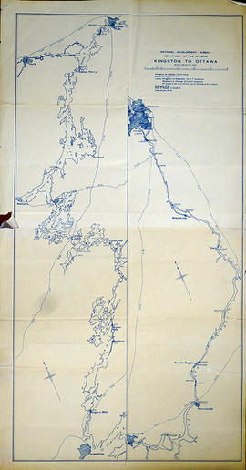
Part of Map collection
A map of Kingston to Ottawa, Ontario published by the National Development Bureau's Department of the Interior, circa 1930. The map features locks, bridges, waterways and settlements. Scale 2 miles to an inch. Written on the back, in ink, is "canoe trip." Presumably a tool of direction for someone's voyage.
Donated by the Belleville Public Library in 2014.
Canada. Department of the Interior
Map of Lennox and Addington, Frontenac and Prince Edward Counties.
Part of Map collection
A map of Lennox and Addington, Frontenac and Prince Edward Counties as of April 1st, 1974. Published by Engineering Plans Office, Cartography section. Produced by the Ministry of Transportation and Communications. Map features information regarding roads, settlements, boundaries, parks and transportation. Scale: 1:250,000. Dimensions: 71cm x 56cm.
Ontario. Ministry of Transportation
Road Map of Belleville, Trenton, Kingston, 2004
Part of Map collection
A Road Map of Belleville, Trenton, Kingston in 2004. Scale 1cm : 0.25 km. Composed by Peter Heiler Ltd. Published by Map Art Publishing.

Part of County of Hastings records
Digital copy of 1899 Union Publishing Company's directory of the Counties of Frontenac, Hastings, Lennox, Addington, Prince Edward