- CA ON00156 TR/2954
- File
- 1615
File contains documents and a newspaper clipping about the early years of Trenton's history. It begins c.1615, and ends around c.1919.
130 results directly related Exclude narrower terms
File contains documents and a newspaper clipping about the early years of Trenton's history. It begins c.1615, and ends around c.1919.
Reproduction Map of Carte de la nouvelle France
Part of Map collection
A reproduction of Carte de la nouvelle France by Samuel de Champlain in 1652. Includes regions to Virginia, from Newfoundland to Lake Superior.
Archives of Ontario
Reproduction Map of Le Canada and Nouvelle France
Part of Map collection
A reproduction of Le Canada, ou Nouvelle France map by Nicolas Sanson. Original map made in 1656. Includes area extending from west Lake Superior to Newfoundland.
Canada. Department of Energy, Mines and Resources
Reproduction Map of Amerique Septentrionale
Part of Map collection
A reproduction of "Amerique Septentrionale divisee en ses principales parties ou sont distingue's les vns des autres Les Estats" map by Nicolas Sanson. Original map made in 1695. Includes area in modern day Canada and USA.
Canada. Department of Energy, Mines and Resources

An Accurate Map of Canada with the adjacent Countries
Part of Map collection
A reproduction by the Canadian Department of Energy, Mines and Resources of "An Accurate Map of Canada with the adjacent Countries Exhibiting the late Seat of War between the English & French in those parts." Original map was issued in 1761 at London. Includes the areas named; New South Wales, New Britain, Canada, south Louisiana, Virginia, "Pennsilvania," New York and New England. The names and location of Indigenous peoples are also featured on the map.
Donated by Gerry Boyce.
Canada. Department of Energy, Mines and Resources
Reproduction of an Accurate Map of North America
Part of Map collection
A reproduction of an "Accurate Map of North America Deferring and distinguishing the British and Spanish Dominions on this great Continent." Original map made in 1775 and held at the Archives of Ontario.
Archives of Ontario
Holland, Samuel – Surveyor General 1783
File contains a 1783 letter from surveyor, W. Samuel Holland, to General Hallimand in Quebec regarding the establishments of settlements along the St. Lawrence and the Mohawks.
Midland District Hastings County Report on Roads, Crt. of Quarter Sess. 1810-30
This file contains a ledger recording roads passed in the Midland District in the County of Hastings from 1810 to 1830. Allan McLean Esq. was acting as Clerk of the Peace of the District. https://en.wikipedia.org/wiki/Allan_McLean_(Upper_Canada_politician)
these were recorded by James Nichollas, Clerk of the Peace, Midland District.
Myers, J., Harrowsmith, Ontario : life story
File contains a typescript biography entitled "An Eventful Career," concerning the life of Harrowsmith, Ontario resident J. Myers, militia member in the 1837 rebellion, and prospector in the California Gold Rush in 1853.
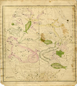
Geography of the Heavens - a Celestial Atlas
Part of Map collection
A "Celestial Atlas designed to illustrate the Geography of the Heavens" by Elijah Hinsdale Burritt, an American astronomer and mathematician. This second edition was published in 1833 by F. J. Huntingdon in the Clerk's Office of the District Court of Connecticut. The pages are as follows:
Burritt, Elijah Hinsdale
Part of Map collection
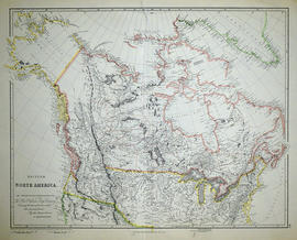
A reproduction by the Canadian Department of Energy, Mines and Resources of "British North America by Permission dedicated to The Honorable Hudsons Bay Company containing the latest information which their documents furnish by their obedient servants." The map was originally composed by John Arrowsmith in 1834.
Donated by Gerry Boyce.
Arrowsmith, John
Reproduction Map of Upper Canada East Part
Part of Map collection
A reproduction of a map of "Upper Canada East Part" by L. J. Herbert in January 1839. Scale in British miles. Published by the Lithographic Establishment Quarter, Master Generals Office.
Archives of Ontario
Nightingale, Thomas : diary 1867
File contains an article from The Intelligencer, 26 July 1967 which includes excerpts from the diary of Thomas Nightingale, a resident of Huff's Island, recounting his journey up the Madawaska River and portions of northern Hastings County in 1867.
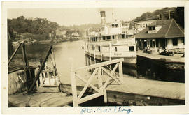
The fonds consists of 633 photographs, 23 negatives, letters, sympathy cards, business cards, newspaper clippings, genealogy and family history and a few business papers belonging to the Smith family, primarily Frank Smith of Madoc. The photographs found in this fonds mainly depict the area around Madoc, with some from Bancroft, Maynooth and other places in Hastings County. A large number of the photographs were taken on vacation or while travelling through Canada and the United States. The photographs were taken in Florida, Atlantic City, Pittsburgh, New Jersey, Philadelphia, Healy Falls, Shaw Falls, Coppercliffe, Ottawa, Port Carling, Gaspe, Napanee, Madoc, Bancroft, Manitoba, Saskatchewan and New Brunswick.
The families primarily depicted in the photographs are the Smith family, McCaw family, Swayne family and Cassidy family. Many of the photographs have names and places written on the back of them. Other people mentioned on the photographs include: Jean Phillips Thompson, Mary Smith Barton, Aunt Vera, Muriel Smith, George Wright, Hugh Pepper, Frank Smith, Frank and Jane Packer Ingersoll, Elizabeth Baker, Martin Porter, Kay Seaton, Helen Whycock, Bessie Woods, Tom Ross, Jack and Ann Yonkers.
There are 3 letters from Henry and Eliza Smith between 1872 and 1874; a birth certificate for Frank Smith, news clippings on the Smith and McCaw families and events in Madoc. There are also family trees and other genealogical information connecting the Smith, McCaw and other families. Much of the information appears to have been gathered by Mary Elizabeth Barton (born Smith: lived from 1921 to 2017).
Smith (family)

Map of the Great Lakes with French Missionary notes
Part of Map collection
A map of Lake Ontario and the land surrounding it, with notes, presumably written by French explorers. Original date 1670, reprinted July 7, 1882.
Part of the Mika collection.
File contains a typescript history by the senior pupils, SS#1 Sabine and their Principal, Mrs. Margaret Foster, concerning the history of Sabine Township in Nipissing District. The history discusses links to early settlers from north Hastings County, including L'Amable Lavalley who settled in Hay Lake from the Baptiste-Bancroft area in 1894.
Corby's cattle boat – Trip to England 1891
File contains a retelling of a Corbyville boy traveling on a cattle boat to England in 1891.
Excursion Tickets 1000 Islands 1898
File contains an excursion ticket from 1898 for a trip from Toronto to 1000 Islands via the Bay of Quinte.
Discovery of Bay of Quinte From OHS Vol. 5, 1904
File contains a copy of a letter to Gerald Boyce from the Public Archives of Canada, and a copy of 'Discovery of Bay of Quinte' by James H. Coyne.
History of Napanee, Newburgh and Yarker
File contains photocopies of chapters from the Lennox & Addington Historical Society on the history of: Napanee, Newburgh and Yarker and Vincinity.