- CA ON00156 2010-41
- Item
- c.1980
Map showing the location and dates of shipwrecks around the shoreline of Prince Edward County.
Ralley, Allan A.
102 results directly related Exclude narrower terms
Map showing the location and dates of shipwrecks around the shoreline of Prince Edward County.
Ralley, Allan A.
Belleville and Suburban Planning Board minutes and reports
Bound reports and minutes of meetings of the Belleville and Suburban Planning Board.
City of Belleville. Planning Department

Photographs of 1981 spring flood in Belleville, Ontario
Sixteen colour photographs of ice and flooding along the Moira river in Belleville, Ontario.

Two photographs:
1) Portrait of a seated man and small child, possibly members of the Walmsley family, taken by D. A. Weese of 279 Front Street, Belleville, Ontario
2) View of floodwaters from CPR tracks near Dundas Street West in Belleville, Ontario, March 1936
Weese, Durwood Alexander
Belleville environmental reports
Collection of reports on environmental issues:
1) Zwick's Island Landfill Environmental Investigations Final Report by the Ontario Ministry of the Environment, October 1991
2) Interim Status Report South Front Street Reconstruction and Meyer's Pier Park Development by Golder Associates, March 1994
3) Phase I-IV Environmental Site Assessment of the Meyers Pier Park Development, Draft Final Report Volume I, by the City of Belleville Parks and Recreation Department, September 1996
4) Bayshore cleanup newspaper clippings, 1995-1998
Photographs and negatives of Belleville Parks
Part of Records of the City of Belleville's Recreation department
Collection of photographs and negatives mostly of parks in Belleville, including mini-golf course. Also a Belleville Garden Club mounted Trillium Award given to the Belleville Parks and Recreation Department in recognition of its outstanding city beautification in 1996.

Collection includes photographs taken by Howard Aselstine, mainly of floods in Belleville, Ontario, in 1918, and a file of materials relating to the 50th reunion of the class of 1930-1931 of King George Public School in Belleville (held on 20 June 1981), compiled by Dorothy Aitchison, one of the organizers.
Aselstine, Howard
Booklet produced by the Friends of McGeachie about the McGeachie Conservation Area on Steenburg Lake in Limerick Township, Hastings County, Ontario.
Friends of McGeachie
Photographs by Bobby-Jo Morris
Colour photographs taken by Bobby-Jo Morris of two events:
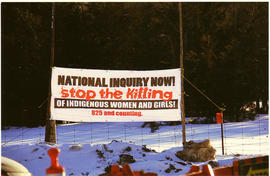
1) Protests on the Tyendinaga Mohawk Territory concerning missing and murdered Indigenous women, 4 March 2014 (16 photographs and four pages of explanatory notes)
2) Flooding in Foxboro, Belleville and Millton, Ontario in April 2014 (30 annotated photographs)
Morris, Bobby-Jo
Quinte Field Naturalists records
Records of the Quinte Field Naturalists consisting of:
Quinte Field Naturalists
File of Ontario Highway Department photographs
Part of Lewis Zandbergen collection
Photographs showing a crew of men from the Ontario Department of Highways, Ottawa District, cutting down tree limbs. Three photographs show trees with trunk or branches growing at right angles to the rest of the tree.
Source Areas Reforestation Land and Existing Woodland, Moira Watershed, No. 1, North Section
Part of Lewis Zandbergen collection
Printed map showing the extent of forests and location of fire lookout towers in the northern part of the Moira River watershed in Hastings County, around Skootamatta and Lingham lakes [Grimsthorpe Township].
Photographs of 1918 Belleville flood
Photographs of flooding and ice in Belleville in 1918, taken by Kathryn Cummins (born Kathryn Millan in 1900).
Cummins, Kathryn

Photographs of 1936 Belleville flood
Five annotated photographs of Belleville, Ontario, taken during the March 1936 floods.
Benson, Frank

Belleville flood photographs and postcard publication
A heart-shaped publication of mini-postcard images of Belleville produced by Charles B. Scantlebury in 1907.
Two photo-postcards of Belleville, Ontario, during spring flooding [possibly 1936], one showing the broken footbridge, the other taken on Bridge Street West.
Scantlebury, Charles B.
Reports and plans relating to water services in Belleville and Thurlow
Five reports and six accompanying plans prepared by Gore & Storrie, consulting engineers of Toronto, relating to proposed improvements to the water and sewerage system in and around the City of Belleville between 1955 and 1969. Copies of water agreements between Public Utility Commissions and municipalities in Whitby (1935) and Brantford, Ontario (1946).
City of Belleville

Postcards of Belleville floods in 1936
Fourteen postcards of scenes in Belleville, Ontario during the March 1936 floods.
Two maps:
1) Plan of Belleville Harbour area, South Front Street, South Church Street, South John Street and South George Street, showing filled-in city dump area and former shoreline, by John T. Ransom, 1947
2) Plan of the mouth of the Moira river, showing the CPR railway bridge and filled-in land, by Tom Ransom, 1961
Ransom, John Thomas, P.L.S.

Moira River Conservation Authority Progress and Achievements, 1947-1962
Printed report on the activities of the Moira River Conservation Authority in Ontario, including maps and photographs.
Moira River Conservation Authority
Photographs of archaeological artifacts
Black and white photographs of archaeological sites and Indigenous artifacts recorded by archaeologist Russell J. Barber in his archaeological survey of the Moira Valley in 1975.
Barber, Russell J.