- CA ON00156 TR/0874
- File
- 1968
File contains a newspaper clipping regarding the 1967 sale of the Cannifton Grist Mill and an article regarding the Cannifton Grist and Sawmill destroyed by fire.
29 results directly related Exclude narrower terms
File contains a newspaper clipping regarding the 1967 sale of the Cannifton Grist Mill and an article regarding the Cannifton Grist and Sawmill destroyed by fire.
File contains newspaper clippings about the people of Cannifton, including a photo of the 1911 Boy Scouts and a 60th wedding anniversary announcement for Mr. & Mrs. Ryan Keller in 1957.
Cannifton – memories 1968; Rush, Mrs. Louise
File contains a Christmas letter touching on memories from Cannifton.
File contains a newspaper clipping about the Corbyville Women's Institute (W.I.) acquiring a new hall.
Cannifton – St. Mark's United Church annual report 1967
File contains the 1967 Annual Report of St. Mark's United Church in Cannifton.
Crime jail break Cannifton 1969
File contains a newspaper clipping about a man who escaped from a Montreal jail was recaptured in Cannifton.
Hastings Militia, Cannifton : Limits of Company 1861
File contains a manuscript Battalion order issued to Capt. Joseph Canniff, 1st Battalion Hastings Militia to call out service men for muster at Cannifton in January, 1862. Also contains a completed printed form entitled Limits of Company, which lists members of Capt. Canniff's militia company in 1861 by name, rank and marital status.
Canniffton Bridge, Thurlow 1865 Tenders
File contains an assortment of documents and petitions, regarding roads and bridges in The Township of Cannifton c. 1865.
Thurlow Township : miscellaneous notes / by Mrs. Mary Plumpton
File contains manuscript notes by Mary Plumpton including lists of Thurlow Town Clerks, 1798-1846; transcripts of pages from an unidentified diary 1870-1872, and notes on individuals appearing in Plumpton's work, The Rambling River. Also present is a photocopied printed excerpt from the 1879 Hastings County Directory with entries for Canifton[sic] listing residents by name and occupation.

Newspaper article on the Cannifton house.

Maribeth Bird photograph collection
Photographs of members of the Winsor, Holgate and Searle families of Hastings County, Ontario and the Cannifton Mills of Charles Arthur Holgate.
Bird, Maribeth Lillian
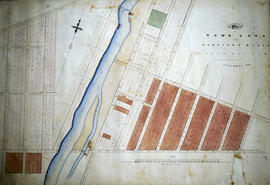
Plan of town lots at Canniff's Mills
Part of Map collection
An original hand-painted, paper-on-linen map. The map was drawn in December 1853 for Joseph Cannif Esq. The area covers proposed town lots in Canniff's MIlls (Cannifton) which were never actually developed. Scale: 2 chains to one inch.

Plan of Lots 5 and 6 in Canniffton
Part of Map collection
A certified reproduction of the "Plan of Part of Lots # 5 & 6 in Concession 2, Township of Thurlow. Land owned by Jonas Canniff, or sold by him. ” The area contained includes; land on East side of the Moira River and on both sides of the Road from Belleville, 128 acres in Canniffton. Originally surveyed by John Emerson, P.L.S. and produced on January 13, 1861.
This reproduction was made on June 5, 1972 and approved by the Deputy Registrar.
Donated by Walter I. Watson, P. L. S.
Emerson, John, P.L.S.
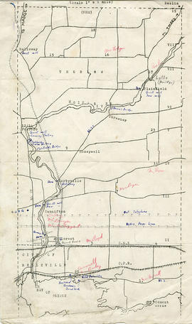
Map of Thurlow Township with annotations
Part of Map collection
A map of Thurlow Township featuring the addition of handwritten annotations. Concessions, railways, proprietors, businesses and locations are featured. The map extends from the Bay of Quinte in the southwest to Roslin the northeast. Circa 1950 (Bakelite plant opened c. 1948 and the Foxboro Cheese Factory closed in 1961).
Specific annotations are as follows: Halloway Grist Mill, Latta Bridge, Plainfield Grist, Saw Mill, O'Brien's Bridge, Grist Mill, Canning Factory Foxboro, Footbridge, Cheese Factory, Fairfields Bridge, Dam Corbyville, Distillery, Cannifton Dam, Grist & Saw Mill, Quarry & Substation, Round House, Brickyard, Graham's Dried Foods, Bell Telephone Lines, Hydro Power Lines, and Cement Works.

Subdivision of Lots 5-7 in west Cannifton
Part of Map collection
A certified reproduction of the "Plan shewing subdivisions of Lots # 5, 6 & 7 in 3rd Concession, Thurlow, west side of River Moira, formerly the property of the late Daniel Canniff in 1856." It was redesignated as “West Cannifton" by Jonas Canniff on August 9, 1862. Surveyed by Publius V. Elmore, P. L. S. Certified by John J. Haslett, P.L. S.
This copy was made in 1972 of plan #124, as registered in the Hastings Land Registry Office.
Beyond the bridge over River Moira and northerly are large lots named: 1. Elizabeth A. Ketchepaw; 2. Letty S. Belch; 3. Thomas Canniff; 4. Philean Canniff; 5. Nancy Canniff; 6. Daniel Canniff; 7. Sarah Mormon; 8. Anne Maria Burnes; 9. Catharine Brown.
Elmore, Publius Virgillius, D.P.S.

Plan of Moira in the Township of Thurlow
Part of Map collection
A certified reproduction of the "Plan of Moira on part of Lot # 6 in 2nd Concession of Thurlow Township for Jones [Jonas] Canniff." Surveyed by John Emerson, P.L.S. and signed April 1853.
This copy was made in 1972 of plan #10, as registered in the Hastings Land Registry Office.
Donated by Walter I. Watson, O.L.S.
Emerson, John, P.L.S.

Plan of Canniff-Ville in Thurlow
Part of Map collection
A certified reproduction of the Plan of Canniff-Ville on part of Lots # 5 and 6 in 2nd Concession of Thurlow Township for Jonas Canniff. Surveyed by John Emerson, P.L.S. and signed December 4, 1849.
This copy was made in 1972 of plan #46, as registered in the Hastings Land Registry Office.
Donated by Walter I. Watson, O.L.S.
Emerson, John, P.L.S.

Plan of Victoria in the Township of Thurlow
Part of Map collection
A certified reproduction of the Plan of Victoria on part of Lot # 6 in the 2nd Concession of Thurlow, for the executors of the late James Canniff. Surveyed by John Emerson, P.L.S. and signed July 31, 1851.
This copy was made in 1972 of plan #47, as registered in the Hastings Land Registry Office.
Donated by Walter I. Watson, O.L.S.
Emerson, John, P.L.S.

Plan of Subdivision of Lot 5 in Canniff's Mills
Part of Map collection
An original plan of subdivision of Lot # 5 in the 3rd Concession of Thurlow Township, referred to as “Canniff Mills,” for Joseph Canniff.
Surveyed by John Emerson, D.L.S. and signed July 31, 1852.
Emerson, John, P.L.S.
Collection comprises:
1) File of genealogical information on Dr. William Canniff
2) Canniff family correspondence, 1902-1920
3) News clippings about Dr. William Canniff, 1952-1983
4) Photographs of family members and Canniff properties in Cannifton, c.1890-1969
Canniff (family)