Canada

Taxonomy

Code

Scope note(s)

Source note(s)

Display note(s)

Equivalent terms

Canada

Associated terms

Canada

185 Archival description results for Canada

15 results directly related Exclude narrower terms

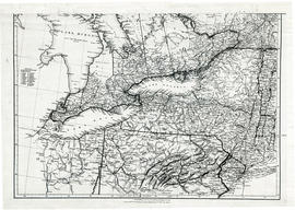
Maps of the Districts of Upper Canada

4 maps showing the Districts of Upper Canada between 1788-1849:

  1. Province of Upper Canada, original districts of 1788 and districts in 1802 (District boundaries 1788, dotted line, District boundaries 1802, solid line)
  2. Province of Upper Canada, original counties, ca. 1793
  3. Province of Upper Canada, districts in 1836
  4. Province of Canada West, districts in 1849

Map of Townships by waterfront and Mohawk Territory

Map showing townships by the waterfront of the Bay of Quinte and the Mohawk Territory. This area encompasses townships in both Prince Edward and Hastings Counties. Text on map says "District of Nassau." Dated 1790. Map copied from the Archives of Ontario.

Reproduction of a map of Upper Canada

  • CA ON00156 M/M400-1000
  • Item
  • Mar. 1792 - Sept. 1795
  • Part of Map collection

Reproduction of a map showing "the Routes Lt. Gov. J. G. Simcoe took on trips" throughout Upper Canada from March 1792 to September 1795. The map was charted by Lt. Gov. Simcoe. A good depiction of the area now referred to as Southern Ontario and his plans for a capital there - "London." This map was published as part of "Charting Our Past" from the Archives of Ontario by Stonehouse Publications.

Scale: about 20 miles to an inch.

Reproduction of a map of the province of Upper Canada

Reproduction of a map showing new settlements, townships, counties etc.in the province of Upper Canada as of April 12, 1800. The total area spans from Quebec to Lake Huron and from Lake Michigan to New Hampshire then south to Pennsylvania in the U.S.A. This was the first printed map of Upper Canada, showing all settlements since 1784. Charted by D. W. Smith, Esq., Surveyor General London and published by W. Faden.

This map was published by Stonehouse Productions as part of "Charting Our Past" from the Archives of Ontario.

Smith, David William

Map of Lower Canada, Quebec and Ontario

A reproduction of part of a map showing Lower Canada, Quebec and Ontario in 1825. Map shows bodies of water and names of settlements. The boundary of Lower Canada is according to a treaty with the United States. From the Archives of Canada on July 27, 1966. Donated by Chewett.

Map of Upper Canada and United States

A map showing settlements of Upper Canada and part of the United States in 1834 by J. Arrowsmith.
Received from the Archives of Canada's map collection - July 9, 1971.

Arrowsmith, John

Parts of Ontario and USA in 1834

A map showing settlements of Ontario and part of the United States in February 1834 by J. Arrowsmith. The total area extends from Lake Huron East to Montreal and south Ohio to Long Island.
Received from the Archives of Canada's map collection - 11 May 1977.

Arrowsmith, John

Map of District of Prince Edward County

Map showing townships in the District of Prince Edward County: South Murray, Sidney, Thurlow, Ameliasburgh, Sophiasburgh. See boundary lines on map. Surveyed by Publius Virgillius Elmore, D.L.S. Dated 1835. Map copied from the Archives of Ontario.

Elmore, Publius Virgillius, D.P.S.

Map of Districts of Prince Edward and Midland

Map showing counties, townships, concessions and lots in the Districts of Prince Edward and Midland. Surveyed by Publius Virgillius Elmore, D.L.S. Published by Hallowell U.C. Dated 1836. Scale 160 chains : 1". Map copied from the Archives of Ontario.

Elmore, Publius Virgillius, D.P.S.

Reproduction of a map of Canada West, formerly Upper Canada

Reproduction of a map showing regions within "Canada West, formerly Upper Canada " 1850. The map is divided in 3 parts: Canada West formerly Upper Canada, part 2 Vicinity of the Falls of Niagara and part 3 The City of Toronto and its environs. In 1849, the County succeeded the District as the division for municipal and judicial purposes in Canada West. That along with recent transportation developments. Composed and published by Thomas Cowperthwaite & Co. in the Clerk Office of the District Court of the Eastern District of Pennsylvania.

This map was published by Stonehouse Productions as part of "Charting Our Past" from the Archives of Ontario.

Cowperthwaite, Thomas & Co.

Map of Hastings, Frontenac, Lennox and Addington 1850 reprint

Map showing Counties of Hastings, Frontenac, Lennox and Addington and the townships within. Legend shows boundaries of counties and townships, plank and graveled roads, other roads and canals. Surveyed by W. H. Smith. Published by MacLear. Scale 5 miles : 2 cm. Reprinted map from “Canada”: Past, Present, and Future. Original map dated 1850.

Smith, W. H.

Huyck Islands claimed by Alnwick Indians

An original, waxed linen map entitled "Islands claimed by Alnwick Indians, Pursuant to Instructions bearing date Crown Lands, Dept. Quebec 2nd October 1861." The area in mention concerns the Huyck Bay Islands, Lake Ontario, and Pleasant Bay. Surveyed by Duncan McDonell Greenfield and John McNaughton, P. L. S. in May, June, July and August, 1862. Scale: 8 chains to an inch.

McNaughton, John, P.L.S. & D.P.S.

West Lake Islands claimed by Alnwick Indians

An original, waxed linen map entitled "Islands claimed by Alnwick Indians, Pursuant to Instructions bearing date Crown Lands, Dept. Quebec 2nd October 1861." The area in mention concerns the West Lake Islands, in Prince Edward County. Surveyed by Duncan McDonell Greenfield and John McNaughton, P. L. S. in May and June 1862. Scale: 8 chains to an inch.

McNaughton, John, P.L.S. & D.P.S.

Weller's and Hay Bay Islands claimed by Alnwick Indians

An original, waxed linen map entitled "Plans of Islands claimed by the band of Alnwick Indians. Pursuant to Instructions bearing date “Crown Lands Department” Quebec 2nd October 1861." The area in mention concerns Weller's Bay and Hay Bay, in Prince Edward County. Surveyed by John McNaughton, P. L. S. in April and May 1862. Scale: 8 chains to an inch.

McNaughton, John, P.L.S. & D.P.S.

Reproduction of map of Province of Canada, western sheet

Reproduction of a map showing regions of the western part of the province of Canada, in 1865. It features transportation and urban developments two years before Confederation, along with increased knowledge of the topography in northern regions, particularly in Canada East. Elevations are given for the Huron and Ottawa territory. Composed by Keith Johnston F. R. S. E. Published by W. & A. K. Johnston Edinburgh.

This map was published by Stonehouse Productions as part of "Charting Our Past" from the Archives of Ontario.

Johnston, Keith, F.R.S.E.

Map of Marmora Township

Map showing concessions, traveled roads and lots of Marmora Township, Hastings County. Areas of gold mines are also charted. Scale: 1 mile : 1 inch. Published by MacLeod & Carre Engineers and Surveyors in Belleville, Ontario (Canada West). Local advertisements surround map.

Received from the Public Archives of Canada on 3 May 1971.

MacLeod and Carre, P.L.S.

Reproduction Map of the City of Belleville with Wards

A reproduction of a Map of the City of Belleville from the Archives of Ontario. The names and locations of the 7 wards in 1874 are featured: Coleman Ward, Bleecker Ward, Ketcheson Ward, Murney Ward, Foster Ward, Baldwin Ward and Samson Ward. This per the Proclamation of Lieutenant Governor of Ontario on September 4, 1874.

Archives of Ontario

Results 1 to 20 of 185