Canada

Taxonomy

Code

Scope note(s)

Source note(s)

Display note(s)

Equivalent terms

Canada

Associated terms

Canada

45 Archival description results for Canada

2 results directly related Exclude narrower terms

Map of Madoc Township

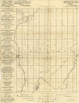
A map showing concessions and lots of Huntingdon - Madoc Township, Hastings County. Circa 1869. 30 advertisements for companies surround the map. Published by Macleod and Carre, Engineers and Surveyors. Scale: 1:63,000. Dimensions: 34.0cm x 37.0cm. Map was created from Government plan.

Donated from the Col. W. N. Ponton Estate. Penciled notes on map show Ponton family's interest in mining, especially after the Eldorado Gold Rush in 1866.

MacLeod and Carre, P.L.S.

Map of Cashel Township

A map showing concessions and lots of Cashel Township, Hastings County. Circa 1869. 13 advertisements for companies are present on the left-hand side. Published by Macleod and Carre, Engineers and Surveyors. Scale: 1:63,000. Dimensions: 29.0cm x 33cm. Map was created from Government plan.

Donated from the Col. W. N. Ponton Estate. Penciled notes on map show Ponton family's interest in mining, especially after the Eldorado Gold Rush in 1866.

MacLeod and Carre, P.L.S.

Map of Elzevir Township

A map showing concessions and lots of Elzevir Township, Hastings County. Circa 1869. 16 advertisements are present on the left-hand side. Published by Macleod and Carre, Engineers and Surveyors. Scale: 1:63,000. Dimensions: 29.0cm x 37.5cm.

MacLeod and Carre, P.L.S.

Plan of the town of Belleville 1869

A copy of a map planning streets and some buildings in Belleville, Ontario, 1869. Produced for the Hastings Directory. Map shows location of schools, court house, churches, banks, post office, town hall, police station, important industries.

Scale: 10 chains to an inch.

Floor plans for L. W. Yeoman's Drug Store

An original hand-painted, paper set of floor plans. The plan was drawn in 1873 for L. W. Yeoman & Company's drug store. The store was located on the corner of Front and Market Streets. The drawings cover the plans for the foundation, ground, second and third floors. Scale: 8 feet to one inch. Published by H. Belden & Company. John Forin built the building.

H. Belden & Company

Bird's Eye View Map of Belleville

Reproduction by the Hastings County Historical Society of an 1874 Bird's Eye View of Belleville, Ontario, showing buildings that existed at that time.

The original map was drawn by Herman Brosius and printed by Charles Sober & Co. of Chicago.

Map of Belleville by Evans & Bolger 1877

An 1877 map of Belleville, Hastings County, Ontario by Evans & Bolger, surveyors. Map includes a table showing dates of plans in the registry office with plan name, wards and dates.

Map of Railway Station, Harbour and Wharf Facilities

A map detailing the Grand Trunk Railway's station (1882), harbour and wharf facilities (1878) in Belleville, Ontario. Legends on each side of the maps describe buildings and areas. By William Michaud.

Michaud, William

Copy of Fire Insurance Map 1878

1878 Fire Insurance Map from Charles Goad's Atlas. Details streets, buildings and lots in Belleville, Ontario. Donated by Beth Green.

Chas. E. Goad Company

Map of City of Belleville and Principal Buildings

A map of Belleville, Hastings County, Ontario and its principal buildings. Produced c. 1878. Scale: 13 chains to an inch. Photocopied from Hastings County Directory at the Archives of Ontario (D-1).

Map of Belleville Harbour Flood Limits and Dredging

A map of the Bellleville Harbour, in July-August 1880, featuring harbour dredging, flood limits of 1879; Flint & Holton's saw mill; Mill Island; Grand Junction Railway. By E. de Bouchinville. Scale: 400ft : 1 inch (original).

de Bouchinville, E.

Map of Parcel of Area #1 - Land Settlement

"In the High Court of Justice - Chancery Division - Morton vs. Ponton. Sketch of Parcel No. ,1 referred to in advertisement of sale therein. "

A map showing a parcel of land between the Bay of Quinte and Dundas Street East (Area #1) in Belleville, Ontario. Published in 1881. Used in land settlement matters. Printed on tissue paper. Scale: 8 chains to an inch.

Map of Dredging in Belleville Harbour

A map detailing harbour improvements, specifically areas to be dredged, in Belleville, Ontario, post 1890. The areas to be dredged are hatched lines, see bottom right Legend. By J. W. Fraser. Scale: 400 ft : 1 inch.

Fraser, J. W.

Carre's Plan of the city of Belleville 1892

A copy of a map planning streets and buildings in Belleville, Ontario, 1892. The total area extends from Belleville to Bay of Quinte to Bridge Street (sheet 2) and from Bridge Street to Concession Road Allowance - now College Street - (sheet 1). Surveyed by Henry Carre, Ontario Land Surveyor.

Scale: 10 chains to an inch.

Carre, Henry, O.L.S.

Dominion of Canada with Hudson's Bay areas

A Map of the Dominion of Canada Shewing the Establishments of the Hudson's Bay Company. Scale: 1:10,500,00. Note the presence of the Districts of Mackenzie, Keewatin and Franklin and the border of Manitoba - circa 1905.

Seymour Power & Electric Co. Limited in Murray Township

  • CA ON00156 M/M430-2998 - 3001/M430-3000
  • Item
  • c.1910
  • Part of Map collection

An original map produced for the Seymour Power & Electric Co. Limited, concerning proposed transmission lines within the Township of Murray. However, the map also features railways, roads, mills and land boundaries. Circa 1910. Scale: 50 chains = 1 inch. Map composed by Smith, Kerry and Chace Engineers located in Toronto, Winnipeg, Calgary and Vancouver.

Donated by David Pershick.

Smith, Kerry and Chace Engineers

Trenton Electric & Water Co. Limited in Sidney Township

  • CA ON00156 M/M430-2998 - 3001/M430-3001
  • Item
  • c. 1910
  • Part of Map collection

An original map produced for the Trenton Electric & Water Co. Limited, concerning proposed transmission lines within the Township of Sidney. However, the map also features railways, roads and land boundaries. Circa 1910. Scale: 50 chains = 1 inch. Map composed by Smith, Kerry and Chace Engineers located in Toronto, Winnipeg, Calgary and Vancouver.

Donated by David Pershick.

Smith, Kerry and Chace Engineers

Trenton/Seymour Electric & Water Co. Limited Maps

4 maps produced for the Trenton Electric & Water Co. Limited and Seymour Power & Electric Co. Limited in the 1910s. The maps contain information regarding water towers, lines and stations.

Smith, Kerry and Chace Engineers

Trenton Electric & Water Co. Limited in Thurlow Township

  • CA ON00156 M/M430-2998 - 3001/M430-2998
  • Item
  • c. 1910
  • Part of Map collection

An original map produced for the Trenton Electric & Water Co. Limited, concerning their water mains, towers and substations within the Township of Thurlow. However, the map also features railways, roads and land boundaries. Circa 1910. Scale: 50 chains = 1 inch. Map composed by Smith, Kerry and Chace Engineers located in Toronto, Winnipeg, Calgary and Vancouver.

Donated by David Pershick.

Smith, Kerry and Chace Engineers

Trenton Electric & Water Co. Limited in Thurlow and Sidney Townships

  • CA ON00156 M/M430-2998 - 3001/M430-2999
  • Item
  • 31 Mar 1910
  • Part of Map collection

An original map produced for the Trenton Electric & Water Co. Limited, concerning proposed transmission lines within the Townships of Thurlow and Sidney. However, the map also features railways, roads, mills and land boundaries. Dated March 31, 1910. Scale: 1/4 mile = 1 inch. Map composed by Smith, Kerry and Chace Engineers located in Toronto, Winnipeg, Calgary and Vancouver.

The map includes the first 4 concessions, Lots 33-38 in Sidney Township and Lots 1-13 in Thurlow Township.

Donated by David Pershick.

Smith, Kerry and Chace Engineers

Results 1 to 20 of 45