- CA ON00156 TR/1044
- File
- 1962
File contains two newspaper clippings concerning the death and commemoration of Hastings County Clerk-Treasurer, Earl .S. Denyes.
27 results directly related Exclude narrower terms
File contains two newspaper clippings concerning the death and commemoration of Hastings County Clerk-Treasurer, Earl .S. Denyes.
Deseronto Election Returns 1961
File contains a newspaper article about the re-election of Sweetnam as Mayor.
Deseronto Change of Name from Millpoint 1880
File contains a notice regarding the application of the Village of Mill Point applying to the Legislature of Ontario to change the name from Mill Point to Deseronto.

Dominion of Canada with Hudson's Bay areas
Part of Map collection
A Map of the Dominion of Canada Shewing the Establishments of the Hudson's Bay Company. Scale: 1:10,500,00. Note the presence of the Districts of Mackenzie, Keewatin and Franklin and the border of Manitoba - circa 1905.

File contains a petition to the Councillors of Hastings County from the inhabitants of Dungannon and Faraday Townships concerning the division of the townships into three school sections. Also contains a directive from the Municipal Council, Hastings County concerning fencing in Dungannon and Faraday Townships.
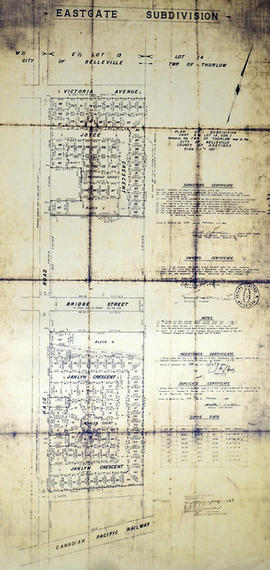
East Gate Subdivision in the City of Belleville
Part of Map collection
A certified reproduction of the "Subdivision of Part of East ½ of Lot # 13, Concession 1, Township of Thurlow, now Belleville laid out for Maple View Realty Ltd. Pres. Maurice Rollins.” The area includes; Lots # 1 to 110 and Blocks A, B, C, D, E, F and Haig Road, Joyce Crescent, Richmond Grove, Janlyn Crescent, Whalen Court, all east of Haig Road. Surveyed by Walter I. Watson, O. L. S. and signed February 10, 1964.
Donated by Walter I. Watson, P. L. S.
Watson, Walter Irvine, O.L.S.

File contains a newspaper article about an election in 1842, the “Most Violent Election in the City”.
Boyce, Gerry
Election Belleville Protest 1850
File contains a notice of petition from 1850, about protesting an election in the Baldwin Ward in Belleville.
Election Canada Advance Polling Stations in Belleville
Part of Map collection
A reproduced map detailing advance electoral polling stations within the City of Belleville. The map includes Bayview Mall, Fire Dept Training Office and St. Mark's United Church as stations, wards and boundaries.
City of Belleville. Information Technology Department
Election Canada Districts in Belleville
Part of Map collection
A map detailing electoral districts #78-503 (inclusive) within the City of Belleville. The map includes polling divisions, road networks and municipal boundaries. Inset No. 7. Federal No. 35073.
Canada. Department of Natural Resources
Election Canada Districts in Centre Hastings
Part of Map collection
2 copies of maps detailing electoral districts #40 to 45 (inclusive) within Centre Hastings. The map includes polling divisions, road networks and municipal boundaries. Inset # 2, # 35073.
Canada. Department of Natural Resources
Election Canada Districts in Deseronto
Part of Map collection
2 maps detailing electoral districts #92, 95-97 (inclusive) and 100 within Deseronto, Hastings County. The map includes polling divisions, road networks and municipal boundaries. Inset No. 6. Federal No. 35073.
Canada. Department of Natural Resources
Election Canada Districts in Monteagle Township
Part of Map collection
2 photocopies of maps detailing electoral districts #1, 2, 5, 8, 10, 19 within Monteagle Township, Hastings County. The map includes polling divisions, road networks and municipal boundaries. Polling Division # 9 and 9(1). Federal No. 35073.
Canada. Department of Natural Resources
Election Canada Districts in Prince Edward County
Part of Map collection
A map detailing electoral districts #183 to 189 (inclusive) within Prince Edward County. The map includes polling divisions, road networks and municipal boundaries. Inset # 9, # 35073.
Canada. Department of Natural Resources
Election Canada Polling Stations in Belleville
Part of Map collection
A reproduced map detailing electoral polling stations within the City of Belleville. The map includes numbered stations, washrooms, parking, roads and parks.
City of Belleville. Information Technology Department
Elections: canvassers' list, 1885.
File contains two copies of a printed booklet entitled “Hints for Canvassers” regarding procedures for canvassing of provincial voters in Ontario municipalities. Includes printed oaths for the voters.
Elections: historical look at ...from MPP Hugh O'Neill
File contains a photocopy typescript of Ontario general election results by political party, for 1967-1990. Also contains a photocopied printed excerpts from the Canadian Parliamentary Guide [formerly Canadian Parliamentary Companion] 1874-1994 including brief biographical sketches of MPPs for Hastings West Riding.
Elections: Quinte & Hastings Ridings, October 1967.
File contains several newspaper clippings regarding polling and election results for Quinte and Hastings ridings in the 1967 Ontario provincial election.
Elections Returning Office 1964
File contains a 1964 booklet “Canada Elections Act: Instructions for the Deputy Returning Officer at an Advance Poll” and an affidavit for voting at an advance poll in Hastings with Mary Plumpton's signature as Deputy Returning Officer.

Electoral Map of the Province of Ontario
Part of Map collection
An Electoral Map of the Province of Ontario, including all of the electoral districts outlined in red. Composed by Surveyor General F. W. Beatty. Published by the Ontario Department of Lands & Forests in 1955. Scale 8 miles to an inch.
Donated by the Argue family in 2013.
Ontario. Department of Lands and Forests