Canada

Taxonomy

Code

Scope note(s)

Source note(s)

Display note(s)

Equivalent terms

Canada

Associated terms

Canada

6090 Archival description results for Canada

133 results directly related Exclude narrower terms

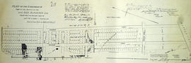
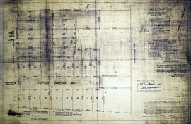
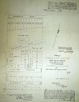
Plan of subdivision of Lot 4 in the Township of Thurlow

A certified reproduction of the Plan of Subdivision on the rear of Lot # 4, in 3rd Concession Thurlow for John Canniff Jr. of Canniff's Mills. Surveyed by John Emerson, P.L.S. and signed November 2, 1853.

This copy was made in 1972 of plan #58, as registered in the Hastings Land Registry Office.

Donated by Walter I. Watson, O.L.S.

Emerson, John, P.L.S.

Plan of Subdivision of Lot 5 in Canniff's Mills

An original plan of subdivision of Lot # 5 in the 3rd Concession of Thurlow Township, referred to as “Canniff Mills,” for Joseph Canniff.
Surveyed by John Emerson, D.L.S. and signed July 31, 1852.

Emerson, John, P.L.S.

Plan of Subdivision of Lots 21-22 in the town of Belleville

A certified reproduction of the Plan of subdivision of parts of Lots # 21-22 on the east side of Front Street in Belleville. Property of Hector Leavens and therefore designated as “Leavens Block”. Surveyed by John D. Evans, P.L.S. and signed June 8, 1870.

This copy was made in 1972 of plan #139, as registered in the Hastings Land Registry Office.

Donated by Walter I. Watson, O.L.S.

Evans, John Dunlop, P.L.S.

Plan of subdivision of Lots 9-10 in St. Ola

A certified reproduction of the "Plan of part of St. Ola, being subdivision of part of Lots # 9 & 10, Concession 1, Limerick Township laid out for Peter Perry Clark.” Surveyed by C. Fraser Aylsworth Jr. P. L. S., and signed October 15, 1887.

This copy was made in 1972 of plan #266, as registered in the Hastings Land Registry Office.

Donated by Walter I. Watson, P. L. S.

Aylsworth, Charles Fraser Jr., O.L.S.

Plan of subdivision of part Lot # 28 in the Township of Thurlow

A certified reproduction of the "Plan of subdivision of part Lot # 28, Reg. Plan No. 65, Township of Thurlow.” The area surveyed includes; east of Herchimer Avenue, being 15 Lots on both sides of Symington Drive. Surveyed by John T. Ransom, O. L. S. and signed June 22, 1955.

This copy was made in 1972 of plan #991, as registered in the Hastings Land Registry Office.

Donated by Walter I. Watson, P. L. S.

Ransom, John Thomas, P.L.S.

Plan of subdivision of part Lots 5-6 in the Township of Thurlow

A certified reproduction of the Plan of subdivision of part of Lots # 5 & 6 in the 3rd Concession of Thurlow, belonging to Jonas Canniff. Surveyed by Samuel M. Benson, P.L.S. and signed on October 20, 1864.

This copy was made in 1972 of plan #103, as registered in the Hastings Land Registry Office.

Donated by Walter I. Watson, O.L.S.

Benson, Samuel Manson, D.P.S. & P.L.S.

Plan of subdivision of part of late George Bleecker Estate

A certified reproduction of the "Plan of the subdivision of part of Estate of Late George Bleecker being part of east half of Lot # 7, Concession 1, Thurlow, now Belleville..." The total area surveyed includes north from the Bay of Quinte to Pine Street and the west side of MacDonald and both sides of Dufferin Avenue. Surveyed by Evans and Bolger, P. L. S. and signed June 26, 1878.

This copy was made in 1972 of plan #211, as registered in the Hastings Land Registry Office.

Donated by Walter I. Watson, O.L.S.

Evans and Bolger

Plan of subdivision of Town Lot 2 in the Township of Madoc

A certified reproduction of the "Plan of subdivision into Town Lots - part of the south half of the east half of Lot # 2, Concession 5, Township Madoc - for June Whytock witnessed by David Whytock.” Surveyed by C. Fraser Aylsworth Jr., P.L.S., and signed April 3, 1889.

This copy was made in 1972 of plan #281, as registered in the Hastings Land Registry Office.

Donated by Walter I. Watson, P. L. S.

Aylsworth, Charles Fraser Jr., O.L.S.

Plan of Summer Lots 10-11 in Township of Marmora

A certified reproduction of the "Plan of Summer Residence Lots as laid out on Lots # 10 and 11 and road allowance between these Lots, Concession 3, Township Marmora.” Surveyed by Fred Wilkins O. L. S., and signed October 9, 1908.

This copy was made in 1972 of plan #351, as registered in the Hastings Land Registry Office.

Donated by Walter I. Watson, P. L. S.

Wilkins, Frederick William Baiden, O.L.S.

Plan of Summer Resorts in the Township of Herschel

A certified reproduction of the "Summer Resort Locations on Baptiste Lake, Herschel Township, being parts of Lot # 8, 9, 10, 11, and 12, Concession 7.” Surveyed by Charles Fraser Aylsworth Jr., O.L.S.and signed January 16, 1939.

Donated by Walter I. Watson, P. L. S.

Aylsworth, Charles Fraser Jr., O.L.S.

Plan of Summer Resorts in the Township of Marmora

A certified reproduction of the "Subdivision for [a] Summer Resort on Lot # 7, Concession 2, Marmora Township. Owner- W. G. Mackechesse.” The area surveyed includes a gore of land between Crow Lake and between Lots # 7 and 8 south to the line between Lots # 6 and 7. Surveyed by Fraser Aylsworth Jr., O. L. S. and signed November 17, 1924.

This copy was made in 1972 of plan #532, as registered in the Hastings Land Registry Office.

Donated by Walter I. Watson, P. L. S.

Aylsworth, Charles Fraser Jr., O.L.S.

Plan of Survey of part Lots 7-8 in the Township of Thurlow

A certified reproduction of the "Plan of Survey of part Lots # 7 & 8, Reg. Plan No. 65, Township of Thurlow.” The area surveyed includes; west of Herchimer Avenue, Lots on both sides of Crestview Avenue and both sides of Rosewood Avenue. Surveyed by John T. Ransom, O. L. S. and signed March 1, 1955.

This copy was made in 1972 of plan #984, as registered in the Hastings Land Registry Office.

Donated by Walter I. Watson, P. L. S.

Ransom, John Thomas, P.L.S.

Plan of survey of part of Dundas Street, Town of Trenton

  • CA ON00156 M/M430-2810
  • Item
  • 15 Apr 1967 - 16 May 1969
  • Part of Map collection

Registered Plans 258, 82, 64 - "Plan of survey of part of Dundas Street, Town of Trenton, showing property frontages and owners." Survey includes; Town of Trenton, part of Dundas Street on 2 sheets, including cross streets Flindal, Herman, Scott, and Campbell.

Allan, Stewart Walker, O.L.S.

Plan of Survey of the Village of Stirling

A plan of survey of part of Blocks D & E, north of Church Street. Registered Plan 149 & Lots 1,2 & 3 Part of Lot # 4, south of Albert Street.

Miller, Paul A., O.L.S.

Plan of Tapson village in the Township of Thurlow

A certified reproduction of the Plan of the village of Tapson on part of Lot # 8 in 3rd Concession Thurlow for Ann Tapson, widow of Ebsworthy Tapson deceased. Episcopal Methodist Parsonage on lot at north end. Saw Mill at south end of plot. Surveyed by John Emerson, P.L.S. and signed April 1, 1853.

This copy was made in 1972 of plan #44, as registered in the Hastings Land Registry Office.

Donated by Walter I. Watson, O.L.S.

Emerson, John, P.L.S.

Plan of Terrace Block in the Township of Thurlow

A certified reproduction of the Plan of Terrace Block, the east half of Lot # 7, 1st Concession of Thurlow, for Messrs Jackson, Peto, Brassey and Betts. Outline of Grand Trunk Railway engine house is north of Belleville Road. Surveyed by Horsey and Nash, P.L.S. in May 1857.

This copy was made in 1972 of plan #91, as registered in the Hastings Land Registry Office.

Donated by Walter I. Watson, O.L.S.

Horsey and Nash, P.L.S.

Plan of the Ashley Block in Foxboro

A certified reproduction of the "The Ashley Block - part of Lot # 2 in Concession 5, Township of Thurlow, Property of Harford Ashley." Surveyed by John D. Evans, P.L.S., and signed in 1874.

This copy was made in 1972 of plan #167, as registered in the Hastings Land Registry Office.

Donated by Walter I. Watson, O.L.S.

Evans, John Dunlop, P.L.S.

Plan of the Bay of Quinte Railway

A photocopy of a Plan of the Bay of Quinte Railway & N. Co. Extension to Ferries to Prince Edward County. Includes Concession III, Lots # 30, 31, 32, 33, 34, 35, 36, 37, & part of Deseronto on the Bay of Quinte. Original map June 20, 1892. Survyed by Matthew J. Butler, O.L.S.

Copy from Band Office through the cooperation of Bruce Povnewy [Polmanter].

Butler, Matthew Joseph, O.L.S.

Plan of the City of Belleville 1958

A map detailing local streets and their respective names, in Belleville, Ontario. Dated July 1958. Written on the map is "Property of the Corby Public Library.

Donated by the Belleville Public Library in 2014.

Plan of the City of Belleville 1960

  • CA ON00156 M/M440-2553
  • Item
  • Oct 1955 - Jan 1960
  • Part of Map collection

A map detailing local streets and land use designations, in Belleville, Ontario. The different types of land use are: O1-greenbelt, O2-parks and playground, R1-single family residential 1st density, R2-single family residential 2nd density, RM1-multi-family 1st density, RM2-multi-family 2nd density, M1-industrial select, M2-industrial light and M3-industrial medium. Composed by C. W. Booth of the City Planning Department in October 1955 and revised January 1960.

Donated by the Belleville Public Library in 2014.

City of Belleville. Planning Department

Results 4081 to 4100 of 6090