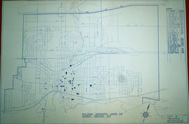
South City of Belleville Map with Property Boundaries in 1976
- CA ON00156 M/M440-2847
- Item
- 23 Feb 1976
Part of Map collection
A map of the City of Belleville, including property boundaries, waterways and roads. House numbers are also included. From Bay of Quinte north to Bridge Street East and from the Moira River east to Foster Avenue. Map composed by the Quinte Planning Board and dated February 23, 1976. Scale 1:2400.
Donated by the Heritage Belleville Committee in 2017.
Quinte Planning Board