Bannockburn

Taxonomía

Código

Nota(s) sobre el alcance

Nota(s) sobre el origen

Mostrar nota(s)

Términos jerárquicos

Bannockburn

Término General Hastings, County of

Bannockburn

Términos equivalentes

Bannockburn

Términos asociados

Bannockburn

6 Descripción archivística resultados para Bannockburn

6 resultados directamente relacionados Excluir términos relacionados

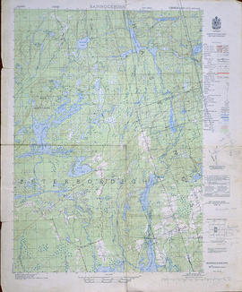
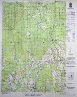
Topographical map of Bannockburn - Canada sheet

  • CA ON00156 M/M470-1559 - 1573, 1576 - 1579, and 1585 - 1621/1564
  • Unidad documental simple
  • 1950
  • Parte deMap collection

A topographical map of Bannockburn - Canada sheet #31 C/12. Published by the Army Survey Establishment, Department of National Defence in 1950. Scale one inch to one mile - 1/63,360.

Donated by Vera Crabbe in 2008.

Sin título

William Freeman railway photographs

  • CA ON00156 2019-015
  • Fondo
  • c.1911

Eighteen photo-postcards of Hastings County scenes, taken by William Freeman. They include images of Bannockburn (2), Eldorado (4), Moscow (1), and Trenton (3). Items donated in 2011 include a photograph of Oran Tripp at Trenton, snapshots of the Rose family of Millbridge, a Model T at Bannockburn in 1911 and three C.N.R. engines at Bannockburn in 1912.

Sin título

Subdivision of Lots 28 in the Township of Madoc

  • CA ON00156 M/M430-1960
  • Unidad documental simple
  • 1 Sep 1887
  • Parte deMap collection

A certified reproduction of the "Plan of subdivision of part of Lots # 28 in Concession 5 & 6 in Township of Madoc, being in the Village of Bannockburn.” Surveyed by C. Fraser Aylsworth Jr. P. L. S., and signed September 1, 887.

This copy was made in 1972 of plan #261, as registered in the Hastings Land Registry Office.

Donated by Walter I. Watson, P. L. S.

Sin título

Topographical Map of Bannockburn - west half

  • CA ON00156 M/M470-1663
  • Unidad documental simple
  • 1950
  • Parte deMap collection

A topographical map of Bannockburn - Canada sheet #31 C/12, west half. Map was published by the Department of National Defence in 1950. Scale 1:50,000.

Donated by Eric Jones.

Sin título

Topographical Map of Bannockburn - east half

  • CA ON00156 M/M470-3055
  • Unidad documental simple
  • 1950
  • Parte deMap collection

A topographical map of Bannockburn - Canada sheet #31 C/12 (east half). Area includes Little Burnt Lake in the north, Crowe Lake and Deloro in the south. From Thompson Lake in the west to Bannockburn in the east. Map was published by the Department of National Defence in 1950. Scale 1:50,000.

Sin título

COR Station at Bannockburn Plans

  • CA ON00156 M/M450-1492
  • Unidad documental simple
  • 19 Jul 1902
  • Parte deMap collection

A blueprint planning the COR station at Bannockburn, Hastings County, Ontario. Plan features floor, platform plans, elevation and sections. Drawn by John Dunlop Evans, Chief Surveyor/Engineer - July 19, 1902.

Sin título